https://nsidc.org/data/seaice_index/images/daily_images/N_iqr_timeseries.png
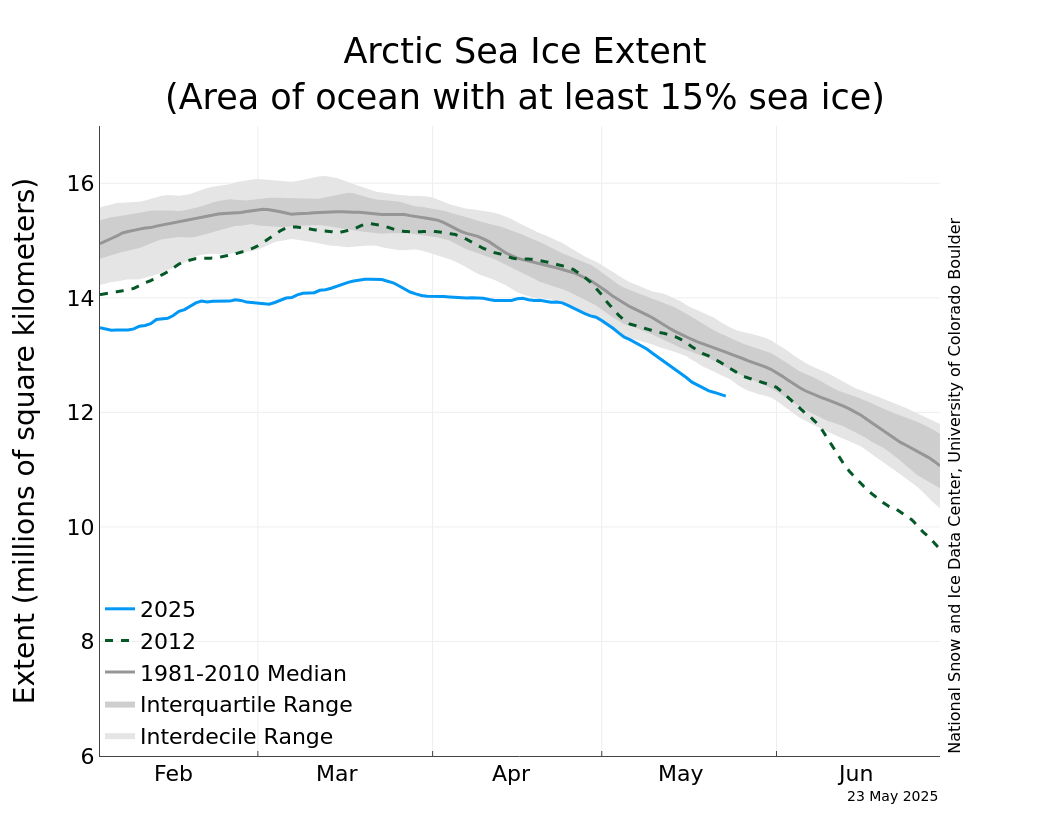
NOTE: The green dashed line is the Sea Ice Extent for year 2012. In September (Summer ice Minimum) of 2012, the SIE broke the record for lowest ice cover of the satellite era, 3.76 million square kilometers. Although winter ice cover is a poor predictor of summer ice cover, the comparison is still useful.
On March 13, 2019, Arctic sea ice likely reached its maximum extent for the year, at 14.78 million square kilometers, the seventh lowest in the 40-year satellite record, tying with 2007. This year’s maximum extent is 860,000 square kilometers below the 1981 to 2010 average maximum of 15.64 million square kilometers and 370,000 square kilometers above the lowest maximum of 14.41 million square kilometers set on March 7, 2017. Prior to 2019, the four lowest maximum extents occurred from 2015 to 2018.
Certainly not a record low maximum by any means, but not exactly a sign of “recovery”, either. Note how all the lows in the maxima have clustered in the 21st century, and most of those in the last decade.
Here are the ten lowest maxima of the last 40 years for which we have reliable data, ranked from low to high ice extents.
2017 14.41 x 10^6 km^2
2018 14.48
2016 14.51
2015 14.52
2011 14.67
2006 14.68
2008 14.77
2019 14.78
2005 14.95
2014 14.96
Early next month NSIDC will publish the average sea ice extent for the entire month of March, and that cute little graph that compares that figure with all the previous March averages since the satellite record began in 1979.
Data: nsidc.org