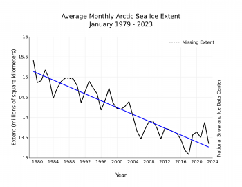
The downward linear trend in January sea ice extent over the 44-year satellite record is 42,500 square kilometers (16,400 square miles) per year, or 3.0 percent per decade relative to the 1981 to 2010 average. Based on the linear trend, since 1979, January has lost 1.89 million square kilometers (730,000 square miles). This is equivalent to about seven times the size of Colorado or about twice the size of Germany.

Sea Ice Extent usually hits maximum in March. But the month to watch is September, when it hits minimum, and the drop in September SIE averages 13% per decade.
But the key takeaway from all this is that no matter what month of the year you pick, the overall trend is always down.